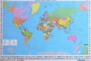
Medium size, 122x86cm (48"x32" approx), political wall map of the world from Freytag & Berndt supplied with metal hanging strips. The map, published in an international edition with all place names in their English versions, presents countries in pleasant pastel colours against light blues seas. On landmasses the map shows main road and rail connections; in USA, Canada, Brazil and Australia also shown are names and boundaries of states/provinces. Physical relief is indicated by names of mountain ranges, peaks, deserts, etc. Polar Regions are presented on insets, showing limits of drift ice and the ice shelf. Latitude and longitude lines are drawn at 10o intervals. Boxes along the sides and the bottom of the map shows each country’s flag, capital city, area and population. Map legend includes English.
Tento web využívá Cooikes pro:
a) nezbytné cookies pro správný chod webu (řazení knih, vkládání knih do oblíbené atd.)
b) anonymní vyhodnocování návštěvnosti (Google analytics)
Natavené Cooikes:
a) nezbytné cookies pro správný chod webu (řazení knih, vkládání knih do oblíbené atd.)
b) anonymní vyhodnocování návštěvnosti (Google analytics)

 Bestsellery
 Novinky